1/24
Map Pad GPS Land Surveys & Measurements screenshot 0
Map Pad GPS Land Surveys & Measurements screenshot 1
Map Pad GPS Land Surveys & Measurements screenshot 2
Map Pad GPS Land Surveys & Measurements screenshot 3
Map Pad GPS Land Surveys & Measurements screenshot 4
Map Pad GPS Land Surveys & Measurements screenshot 5
Map Pad GPS Land Surveys & Measurements screenshot 6
Map Pad GPS Land Surveys & Measurements screenshot 7
Map Pad GPS Land Surveys & Measurements screenshot 8
Map Pad GPS Land Surveys & Measurements screenshot 9
Map Pad GPS Land Surveys & Measurements screenshot 10
Map Pad GPS Land Surveys & Measurements screenshot 11
Map Pad GPS Land Surveys & Measurements screenshot 12
Map Pad GPS Land Surveys & Measurements screenshot 13
Map Pad GPS Land Surveys & Measurements screenshot 14
Map Pad GPS Land Surveys & Measurements screenshot 15
Map Pad GPS Land Surveys & Measurements screenshot 16
Map Pad GPS Land Surveys & Measurements screenshot 17
Map Pad GPS Land Surveys & Measurements screenshot 18
Map Pad GPS Land Surveys & Measurements screenshot 19
Map Pad GPS Land Surveys & Measurements screenshot 20
Map Pad GPS Land Surveys & Measurements screenshot 21
Map Pad GPS Land Surveys & Measurements screenshot 22
Map Pad GPS Land Surveys & Measurements screenshot 23
Map Pad GPS Land Surveys & Measurements Icon

Map Pad GPS Land Surveys & Measurements

Andrzej Bieniek
Trustable Ranking Iconمورد اعتماد
2K+دانلودها
13.5MBاندازه
Android Version Icon4.1.x+
إصدار الأندرويد
7.5.0(19-05-2019)آخرین نسخه
5.0
(2 دیدگاه‌ها)
Age ratingPEGI-3
نحوه نصب
1
فایل نصب را دانلود و باز کنید
2
Unblock AptoideAptoide is a safe app! Just tap on More details and then on Install anyway.
3
نصب را کامل کنید و Aptoide را باز کنید
app-card-icon
جزییاتدیدگاه‌هانسخه‌هاالمعلومات
1/24

توضیحات Map Pad GPS Land Surveys & Measurements

Use MapPad to calculate areas, perimeters and distances and save, export or share your measurements.


MapPad is providing multi-purpose mapping solution allowing location capture and determines distance and area for the shapes drawn on the map or captured using real-time GPS tracking.


Calculate area of the field or a walk distance instantly using Google or Bing Map Satellite view. Save petrol and time and capture features with few clicks on the map.

With MapPad you can capture, manage and share your data easily.


MapPad is a very useful tool for anyone involved in forestry, agriculture, engineering and real estate management.


Please visit our website to find out how to prepare offline map and get more information about this product.


Selected features:


- Base maps: Google Maps, Open Street Map, Bing Maps


- Google Maps Overlays (Custom WMS or ArcGIS Server Tiled service), some layers like US Topographic map have been predefined.


- Very accurate measurement of areas and distances.


- 3 methods of measurement are supported (Tap on the map, GPS location, Map cursor location).


- Support for number of metric and imperial units.


- Support for several global and local coordinate systems, if you require support for any other spatial reference please get in touch.


- Possibility to capture waypoints and group them in categories.


- Possibility to add or edit title and description for each recorded measurement and waypoint.


- Export single or multiple measurements or waypoints to SHP File, Geojson, ArcGIS Json, KML, GPX, CSV and DXF to SD Card or cloud services las well as direct export to Open Street Map.


- Share single waypoint location directly by SMS, E-mail or other ways.


- Elevation profile available for measurements done by GPS.


- Import of KML and GPX files to the application.


- GPS status and satellites status.


- Address, location search.


- Quick open exported KML files in Google Earth


- Ability to set default measurement units, waypoints' categories colours, track recording time and distance interval, transparency of Google Maps overlays and much more...


Our users are successfully using MapPad in number of projects and applications.

از MapPad برای محاسبه مناطق ، محیط و مسافت استفاده کرده و اندازه گیری های خود را ذخیره ، صادرات یا به اشتراک بگذارید.


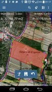
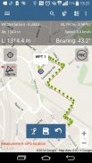
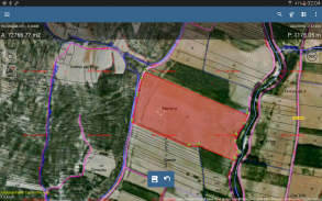
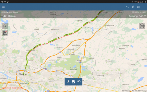
MapPad در حال ارائه راه حل نقشه برداری چند منظوره است که امکان ضبط موقعیت مکانی را فراهم می کند و مسافت و مساحت شکل های ترسیم شده بر روی نقشه را تعیین می کند یا با استفاده از ردیابی GPS در زمان واقعی اسیر می شود.


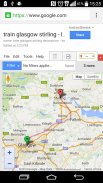
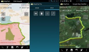
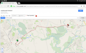
با استفاده از نمای Google یا نقشه نقشه بینگ ، فوراً منطقه یا مسافت پیاده رو را محاسبه کنید. در مصرف بنزین و زمان صرفه جویی کنید و با چند کلیک روی نقشه ویژگی های ضبط کنید.

با MapPad می توانید داده های خود را به راحتی ضبط ، مدیریت و به اشتراک بگذارید.


MapPad ابزاری بسیار مفید برای هرکسی است که در زمینه جنگلداری ، کشاورزی ، مهندسی و مدیریت املاک فعالیت می کند.


لطفاً برای اطلاع از نحوه تهیه نقشه آفلاین و کسب اطلاعات بیشتر در مورد این محصول ، به وب سایت ما مراجعه کنید.


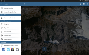
ویژگی های انتخاب شده:


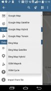
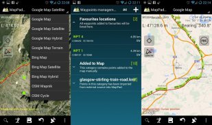
- نقشه های پایه: نقشه های Google ، نقشه خیابان باز ، نقشه های بینگ


- Google Maps Overlays (سرویس Wiled یا سرور ArcGIS سرویس سفارشی) ، برخی از لایه ها مانند نقشه توپوگرافی ایالات متحده از پیش تعریف شده اند.


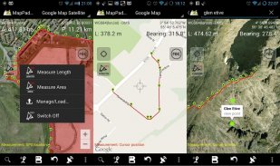
- اندازه گیری بسیار دقیق مناطق و مسافت ها.


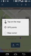
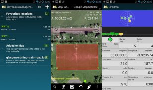
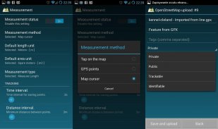
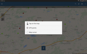
- 3 روش اندازه گیری پشتیبانی می شود (روی نقشه ، محل GPS ، مکان مکان نقشه) ضربه بزنید.


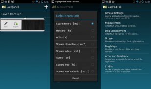
- پشتیبانی از تعداد واحدهای متریک و امپریالیستی.


- در صورت نیاز به پشتیبانی برای هر مرجع مکانی دیگر ، از چندین سیستم مختصات جهانی و محلی پشتیبانی کنید ، لطفاً با ما در تماس باشید.


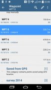
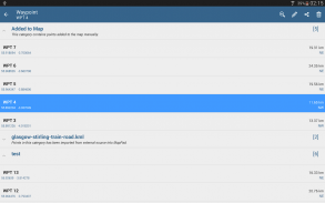
- امکان ضبط ایستگاههای راه و گروه بندی آنها در دسته ها.


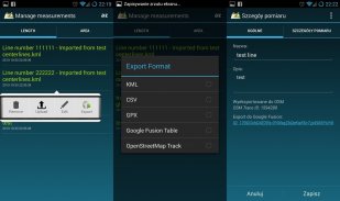
- امکان اضافه کردن یا ویرایش عنوان و توضیحات برای هر یک از اندازه گیری ها و ایستگاه های ضبط شده.


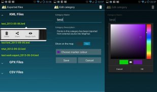
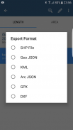
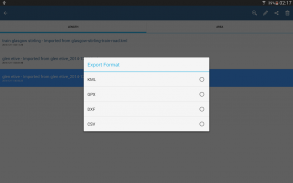
- اندازه گیری های یک یا چند یا چند راه ایستاده به SHP File ، Geojson ، ArcGIS Json ، KML ، GPX ، CSV و DXF را به کارت SD یا خدمات ابری صادر کنید و همچنین صادرات مستقیم را به Open Street Map انجام دهید.


- به اشتراک گذاشتن موقعیت مکانی تک ایستگاه به طور مستقیم از طریق پیام کوتاه ، ایمیل یا راه های دیگر.


- مشخصات ارتفاع در دسترس برای اندازه گیری های انجام شده توسط GPS.


- واردات پرونده های KML و GPX به برنامه.


- وضعیت GPS و وضعیت ماهواره ها.


- آدرس ، جستجوی مکان.


- سریع فایلهای KML را در Google Earth صادر کرد


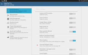
- امکان تنظیم واحدهای اندازه گیری پیش فرض ، رنگ دسته بندی ایستگاههای بین راه ، فاصله زمان ضبط و فاصله فاصله ، شفافیت پوشش های Google Maps و موارد دیگر ...


کاربران ما با موفقیت از MapPad در تعداد پروژه ها و برنامه ها استفاده می کنند.


Map Pad GPS Land Surveys & Measurements - نسخه 7.5.0

(19-05-2019)
سایر نسخه‌ها
تازه‌هاFIX: The app was not working with Android 9 - now fixed.

هنوز هیچ دیدگاه و نظری وجود ندارد! برای ثبت اولین دیدگاه لطفا روی کلیک کنید.

-
2 Reviews
5
4
3
2
1
Info Trust Icon
گارانتی اپلیکیشن خوباین اپلیکیشن تست‌ امنیتی برای ویروس، مالور و سایر حملات خطرناک را گذرانده است و دربرگیرنده هیچ خطری نیست.

Map Pad GPS Land Surveys & Measurements - اطلاعات APK

نسخه APK: 7.5.0حزمة: com.osedok.mappad
سازگاری با اندروید: 4.1.x+ (Jelly Bean)
برنامه‌نویس:Andrzej Bieniekشرایط حریم‌خصوصی:https://sites.google.com/view/mappad-privacy-policyمجوزها:11
نام: Map Pad GPS Land Surveys & Measurementsاندازه: 13.5 MBدانلودها: 949نسخه : 7.5.0تاریخ انتشار: 2023-10-10 19:04:58حداقل صفحه‌نمایش: SMALLپردازشگر پشتیبانی‌شده: x86, x86-64, armeabi, armeabi-v7a, arm64-v8a, mips, mips64
شناسه بسته: com.osedok.mappadامضای SHA1: 72:72:DE:74:E5:41:17:E4:3E:4B:0E:3E:13:9C:42:58:4A:E2:C4:1Fبرنامه‌نویس (CN): Andrzej Bieniekسازمان (O): منطقه (L): Motherwellکشور (C): GBاستان/شهر (ST):

آخرین نسخه Map Pad GPS Land Surveys & Measurements

7.5.0Trust Icon Versions
19/5/2019
949 دانلودها13.5 MB اندازه

سایر نسخه‌ها

7.0.2Trust Icon Versions
16/5/2018
949 دانلودها9.5 MB اندازه
7.0.0Trust Icon Versions
20/12/2017
949 دانلودها6.5 MB اندازه
6.5.2Trust Icon Versions
25/3/2017
949 دانلودها4 MB اندازه
6.5.1Trust Icon Versions
17/12/2016
949 دانلودها4 MB اندازه
6.5.0Trust Icon Versions
16/11/2016
949 دانلودها4 MB اندازه
6.0.5Trust Icon Versions
16/5/2016
949 دانلودها4 MB اندازه
6.0.1Trust Icon Versions
8/12/2015
949 دانلودها4 MB اندازه
5.7.7Trust Icon Versions
5/11/2015
949 دانلودها4 MB اندازه

اپلیکیشن‌ها در دسته مشابه

شاید دوست داشته باشید...